In preparation for the new SFI standards your RPA maps will need to be accurate. This means logging into your RPA account and checking your land covers and hedges are mapped correctly.
Land Cover
Land covers are classified by identifying the physical nature of the land. Land covets will need to be accurate in order to apply for the soil and land standards.
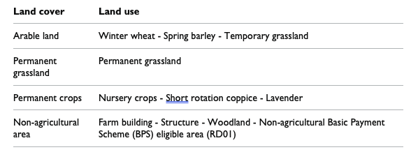
Table 1 shows the 4 land cover groups, and some examples of the land uses in each group.
Land use, as defined on your annual BPS form, is a sub-category of land cover describing the activity carried out under a land cover type. (There is one land use which has the same name as the land cover group – permanent grassland.)

There are 2 ways you can tell us about changes to your land cover.
- Where there is only one land cover change and it covers the whole of the land parcel, you can telephone the RPA on 03000 200 301.
- Where there is more than one land cover for a land parcel, you need to fill in an RLE1 form and send it to us with a sketch map clearly marked with the land covers and areas. If the land cover is non-agricultural, where possible write the land use code from Annex 1 of the RLE1 guidance as this will help us record it correctly. You must also write ‘Mapping change query’ and your SBI on your RLE1 form and sketch map. If you fill in your RLE1 form electronically, you should state in your email that this is a mapping change query.
When you want to tell us about several land parcels, each with only one land cover, it is also better to fill in an RLE1 form than to telephone.
Hedges
Hedges will need to be accurately mapped in order to include them in the new SFI hedge standards or under the hedgerow management options in Mid-Tier.
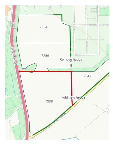
If you disagree with a length of hedge or hedge feature shown in your digital maps (or it’s not shown) you need to send in an RLE1 form and sketch map. The map will need to show the lengths of missing hedges to be added or hedges that are incorrectly mapped to be removed.

